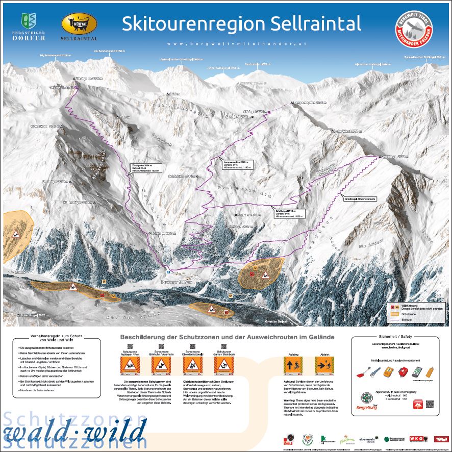
Sellrain Ski Tour Region
Sellrain has a long tradition as a ski tour region. With this project, the mountaineering villages of Sellrain, Gries im Sellrain and St. Sigmund im Sellrain want to develop an environmentally-friendly form of ski mountaineering which takes into account the needs of all nature users in this area.
Protected sites and species
Based on the principles of the “Tyrolean Ski Tour Guidance Plan”, the partners to the “Sellrain Ski Tour Region” project have marked out conservation areas which ski mountaineers should voluntarily avoid. Near the feeding stations there are also officially prescribed wildlife retreats where visitors must keep to the paths and which are best avoided altogether.
Digital map
The exact location of the protection zones for forest and game that we have agreed in the working group can be found here.
![]()
Evaluation of the steering measures
In the winter of 18/19, members of the working group reviewed the success of the steering measures in the field. In doing so, we assessed the density of traces in protected areas according to a uniform scheme and documented it on a smartphone in an APP specially designed for this purpose. The results show that in the majority of the protection zones no or only isolated ski tracks were detected and that only individual areas are more intensively used.
However, there are always changes in the use of space to which we respond through targeted improvement of our steering measures.
Unfortunately, in the winter season 20/21 we had to observe a strong increase in the total frequency and, due to the perfect and mostly safe snow conditions, also tracks on slopes that had hardly been skied so far.
LVS-Checkpoints
Since winter 2015/16 4 LVS Checkpoints are available in Sellrain:
- Lüsens Inn - Schöntalspitze mountain
- Praxmar - Zischgeles, Lamsenspitze and Grieskogel (run by Luis Melmer)
- Haggen - Zwieselbacher Rosskogel, Schöllekogel, Pockkogel
- Fotsch Bergheim - Windegg, Auf Sömen, Hühnereggen, Roter Kogel
In addition to the safety aspect, the stations also provide us with figures about how many ski mountaineers are using the respective tours.
Ski touring aisles
Many traditional ski tours lead in the lowest part also through forest. Especially the sparse forests at the forest border are habitats for some species of animals that are particularly sensitive to disturbance (e.g. black grouse). The Sellraintal working group has tried to find clear lines on which we want to direct the ski tourers through this critical area. Ski touring corridors - these are mostly artificial clearings in the forests - guide ski mountaineers through the forest on the path of least resistance. Such corridors are now available on the following tours:
- Grieskogel (from Praxmar)
- Schöntalspitze
- Roter Kogel (from Moos)
- Roter Kogel (from Fotsch)
Orientation boards
We have installed orientation boards at all the important car parks and huts in the Sellraintal valley These give a clear description of the route, the most important information on the ski tours and the location of the conservation areas. The QR codes provide all the information and background stories about our 4 protected sites and species so that you can understand why you should bypass the conservation area shown.
The information about emergency equipment, the emergency APP and the link to the avalanche report come from our partner Tyrol Mountain Rescue.
Signposting
Conservation areas are marked in open country only at locations where there is direct contact with a ski tour. The directional arrows, which make it possible to bypass or go round, are only used very sparingly. The signs in general are restricted to the area below the tree line. Of 42 ski tours we have designated in Sellrain, this year only 6 are signposted in the forest in order to indicate conservation areas.
The direction signs do not mean that the proposed routes are safe from avalanches and other natural hazards. It is the ski mountaineers’ responsibility to make this assessment themselves.
PDF downloads
-
Haggen.pdf Pdf Version der Karte von Haggen mit eingezeichneten Schutzzonen.
-
Juifen.pdf Pdf Version der Karte von Juifen mit eingezeichneten Schutzzonen.
-
Luesens.pdf Pdf Version der Karte von Lüsens mit eingezeichneten Schutzzonen.
-
Moos.pdf Pdf Version der Karte Moos mit eingezeichneten Schutzzonen.
-
Pforzheimerhuette.pdf Pdf Version der Karte der Pforzheimerhütte mit eingezeichneten Schutzzonen.
-
Praxmar.pdf Pdf Version der Karte des Praxmar mit eingezeichneten Schutzzonen.
-
St_Siegmund.pdf Pdf Version der Karte von St. Siegmund mit eingezeichneten Schutzzonen.
-
Westfalenhaus.pdf Pdf Version der Karte des Westfalenhaus mit eingezeichneten Schutzzonen.
-
panorama_Bergheim.pdf Pdf Version der Karte Bergheim mit eingezeichneten Schutzzonen.
-
panorama_Eisbruecke.pdf Pdf Version der Karte der Eisbrücke mit eingezeichneten Schutzzonen.
-
panorama_Potsdamerhuette.pdf Pdf Version der Karte der Potsdamerhütte mit eingezeichneten Schutzzonen.
The "Sellrain Ski Tour Region” working party
With the Tyrolean Ski and Snowboard Tour Plan, it has been particularly important to us that all stakeholders should have an equal say about all measures and be able to voice their concerns. In the Sellrain working party we have so far been very successful in achieving this and hope that, by virtue of the wide range of stakeholders, all interests have been considered in a balanced way.
Represented in the working group are:
- Communities
- Landowners
- Alpine club (Alpenverein), local guides and tourers
- Tourism association
- Hunters
- Forestry authority
- Nature conservation, rest area Stubai Alps
- Administration Land of Tyrol


